
You're Where?
In which I pretend I'm a geography teacher and help you find Buenos Aires.

Years ago, a series of e-mails with friends, readers, and clients, led me to understand that many people seemed to be under the impression that Argentina is some little dot of a country, somewhere down there (vague hand wave in a southerly direction). I honestly don't mean this to be condescending, so for those of you who take some of the following information for granted, please don't take it that way. I'm responding to actual misconceptions on the part of folk I've corresponded with in various parts of the world. Let's narrow it down bit by bit. [Thanks go out to all the websites that I lifted these maps from.]
.")
First, Argentina is in South America. Not Africa (similar shape, different continent, based on the Gaia theory of continental shift, separated ever so slowly from each other a zillion years ago). Not Australia. It's not the capital of Brazil. Nor Venezuela. You can see on the map that it borders on five other countries - Uruguay, Brazil, Paraguay, Bolivia, and Chile.

And, South America is south and EAST of North America. I'm not sure why, but most folks (including some here) seem to think it's either straight south, or actually west. That means, that during half the year (daylight savings time changes and all that - we don’t do it), in Buenos Aires it's an hour later than in New York and the other half of the year it's two hours. Note also that it's in the southern hemisphere of the planet - roughly the 34 degree south line - the northern equivalent would be a line drawn across Charlotte, NC to Pismo Beach, CA; or going the other way, a line cutting across Casablanca, Beirut, Kabul, and Hiroshima - and we have a similar temperate to hot climate most of the year. Beyond important considerations such as whether water goes down the drain in the opposite circular direction (it does), the seasons are flipped by half a year from the northern hemisphere. When it's winter there, it's summer here, etc.
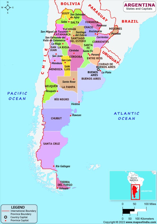
On to Argentina itself, and this colorful display of its 23 provinces. Yes, it's big enough for 23 provinces (plus the autonomous Capital Federal district), at 2,360 miles (3,800 km) north to south and 884 (1,420 km) east to west. In fact, it's just under a third of the size of the United States. As a rough guide, think the continental United States east of the Mississippi River. For Canadians, think of the entire east - Ontario, Quebec, New Brunswick, Newfoundland, and Nova Scotia. For Australians, try Queensland, New South Wales, and Victoria all rolled into one. I don't even want to try to figure out a European comparison - a lot of your countries all bundled up together... Okay, I'll give you one just to give you some perspective... see the province of Buenos Aires in that pale lavender color? That province, and the country of Poland, are the same size. All of the UK would fit very comfortably inside the province, with room for the majority of Ireland. And all that, by the way, doesn't include the fact that Argentina "owns" nearly 375,000 square miles (971,000 square km) of the continent of Antarctica. So, for those planning out their tour itineraries; no, you don't have time for a day trip to see the Iguazu Falls in Misiones, Mendoza wineries in the west, the glaciers of Tierra del Fuego in the south, and wind up back here in the city for a café cortado after lunch.
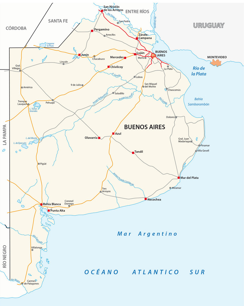
It can be confusing that both the province and the city (the autonomous federal district) of Buenos Aires have the same name. It’s confusing for locals too sometimes, especially when talking about governmental initiatives, since each have their own governments, laws, and… issues. The city, while the capital of the country, is not the capital of the province, which is La Plata, a little less than an hour’s drive southeast of here. Out of the nation's 46 million people (that’s a big increase since I first posted this general guide, almost twenty years ago, when it was 40 million), the city of Buenos Aires, locally designated CABA, or Ciudad Autónoma de Buenos Aires - Autonomous City of Buenos Aires, has a little over 3 million.
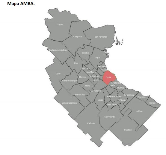
However, when most people talk about it, they talk about the AMBA, el Área Metropolitana de Buenos Aires - the Metropolitan Area of Buenos Aires, which includes 40 suburbs that surround it, and adds in another 13 million. The entire rest of the province only adds in another 2 million. That makes for some 36% of the population of the country living in the metropolitan area. Just as a note of comparison, the next biggest city in the country, Rosario, about a four to five hour drive northwest of here, has two million people including its suburbs (half in the city, half out).

And that brings us to the city of Buenos Aires - originally Ciudad de la Santísima Trinidad y Puerto de Santa María de los Buenos Aires - City of the Holy Trinity and Port of Saint Mary of the Fair Winds. At just over 77 square miles (200 sq. km.) of surface area it's not a small city - not huge, but not small (8.5 x 9 miles / 13.6 km x 14.5 km). As mentioned, roughly 3.1 million people live here. That makes it just slightly larger and more populous than Brooklyn (72 sq. mi. / 186 sq. km. and 2.7 million people). The city is divided into 48 barrios, or neighborhoods, each of which has a fairly distinctive character, much like the various neighborhoods of many a metropolitan city. The areas along the northeastern part of the city are the areas that most tourists see, and many probably don't see all of those, limiting their explorations to Recoleta, Palermo, San Telmo, and Puerto Madero. And, you're unlikely to want to go to many of them, in particular those in the southwest. These traditional barrios are also, for governing purposes, combined into 15 larger comunas, which mostly just affects us when we need something official accomplished, because the comuna office might be in a different, albeit nearby, neighborhood.
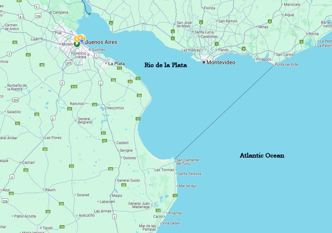
Oh, and back to those misconceptions... Buenos Aires, if you look at the maps, is on the Rio de la Plata - River to the Silver, a river (so called because if you follow it all the way to its origin, you get to the silver mines of Potosí, in Bolivia, or so was the claim). We're not on the ocean, we don't have beaches. You might be thinking about Rio de Janeiro - that's in Brazil. Beaches are south and east of here - for the most part, for beach communities, you're looking at anywhere from a 3-5 hour drive . The most famous are probably Mar del Plata and Pinamar, both of which you can get to by a steady stream of buses throughout the day. Or perhaps Punta del Este, but that's in Uruguay, the neighboring country across the river to the east - and is about a fifty minute flight, or a three hour ferry ride to Montevideo followed by a two hour bus trip. Looking at the map above, the rough point where the water changes from fresh to salt, is the line I’ve drawn connecting the northern point of the province’s beaches with the eastern beaches in Uruguay.
All this information will be on the midterm. You’ve been advised.
THIS IS MARVELOUS. I’m forwarding it to my friends and family who still aren’t sure where I have gone to retire. You even managed to include some things that my porteño boyfriend didn’t know about his city and country. You have become the first site that I visit each day. I can’t get enough of your wit and wisdom.
Great article Dan, very informative. I read the water going down the drain the opposite direction from the northern hemisphere is a myth, but who knows! Great description of the size of the country and neighborhoods and population. Also, no one "owns" Antarctica, I guess that's why you quoted it, I know that Argentina maps show a slice of Antarctica as Argentina, but Antarctica is governed internationally through the Antarctic Treaty System (ATS) it's a continent dedicated to peace and science, managed collectively by the international community. Thanks again for the article! Great job!